
Southern Altiplano road trip
- Jan Dehn

- Dec 19, 2025
- 4 min read

Laguna Colorada in Bolivia (Source: own photo)
I have just completed a very rewarding road trip through the southern Bolivian Altiplano, the second-largest high plateau on Earth after Tibet.
The Altiplano is a 400 kilometres wide elevated section of the Andes mountain chain bordered by even higher mountain ranges to the east and west. The plateau begins in the south near the Bolivian border with Chile and Argentina, where you can actually see the Andean chain splitting into its eastern and western ranges. The two ranges re-converge 1,800 kilometres further north in southern Peru. The bulk of the Altiplano therefore lies within the borders of present-day Bolivia. The southern sections of the province of Potosi was the focus of my trip.
The average elevation of the Altiplano is 3,750 meters above sea level. This is high enough to create hypoxic conditions. Indeed, I experienced rather unpleasant High Altitude Sleep Apnea during my visit, which faded as I gradually became more acclimatised.

Gorgeous coloured mountains (Source: own photo)
The northern sections of the Altiplano tend to be wetter, which is why it has big lakes, including Peru's Lake Titicaca, the largest lake in South America. Toward the south, however, the Altiplano is considerably drier, which is why this part has large salt plains, such as the Uyuni and Coipasa flats. With an area of 10,582 square kilometres, Uyuni is the largest salt pan in the world; 100 times larger than the Bonneville Salt Flats in Utah for context.

Incahuasi Island in the middle of the Uyuni salt flat (Source: own photo)
The Andes is a relatively young mountain range. With an age of 50-65 million years, it was basically formed as a result of continental drift and collision of tectonic plates around the time of the extinction of the dinosaurs (for more information about dinosaur traces in Bolivia see here).
Specifically, the Nazca oceanic plate was subducted beneath the South American plate as the latter drifted westwards. The resulting horizontal compression forces folded and deformed the Earth's surface and pushed material upwards, creating the Andes range. The process was accompanied by frequent earthquakes and the formation of long chains of volcanoes at the tectonic boundaries.

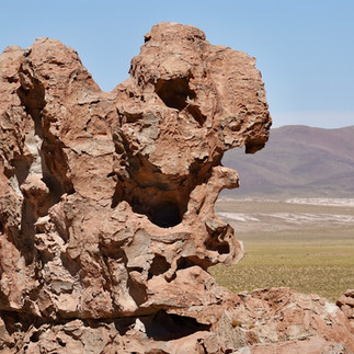
The rocks in the foreground are from the missing bits at the top of the volcano in the background (Source: own photo)
It is quite evident that the collision of the tectonic plates in Bolivia was quite violent, manifested both in early stage erosion in river beds and in the extreme steepness of many of the mountains. In fact, the peak of Mount Chimborazo in Ecuador is actually farther from the Earth's centre than any other place on Earth, including Mount Everest due to the bulge in the Earth at the equator caused by our planet's rapid spin.

Young mountains with clear signs of erosion (Source: own photo)
Moreover, you see clear evidence that considerable amounts of surface material from the subducting oceanic plate was pushed onto the surface of the continental plate in the volume of coral at very high elevations throughout the Altiplano. I found a bunch of it during my visit, particularly around the Valley of the Rocks just north of the town of Villamar.

Basalt rock enveloped in coral at 4.5 kilometres altitude (Source: own photo)
What makes the Altiplano stand out from the rest of the Andes is obviously its width and relatively absence of contours. Why did this wide plateau form right here and not elsewhere in the Andes chain?
The answer is that a number of special geological conditions were present here and not elsewhere, the most important of which was that a broad section of the South American continental plate contained weaknesses, which caused it to crumble under the forces of continental collision, uplifting it across the width of the area of weakness.

Great place for a road trip (Source: own photo)
Related to this, as the Andean mountains gained height they created rain shadows that trapped humidity on the Eastern side. The decline in rainfall reduced lubrication at the subduction zone, which pushed up friction ratios and so transmitted forces horizontally eastwards across the weak section of the South American plate, increasing crumbling further.


Valley of the Rocks (Source: own photos)
In addition, there were likely special conditions in the composition of the Earth's crust far beneath the plateau, which enabled magmatic forces to push the upper layers up from below at this spot. There is also evidence that very dense parts of the lower crust underneath the Altiplano may have detached and sunk into the magma below, thereby enabling the upper layers to float higher.

The Uyuni salt plain is the result of internal drainage. You can also drain other things internally (Source: own photo)
Finally, as cordilleras emerged on each side of the plateau the drainage of rainwater obviously became internal to the plateau, which meant that more and more sediment accumulated on the Altiplano rather than draining into Atlantic or Pacific oceans.
In my opinion, the Altiplano's extreme geology makes Potosi province one of the most beautiful places on Earth. In contrast to Bolivia's forested parts (see here), geology clearly takes precedence over flora and fauna on the Altiplano. Still, we managed to spot a good number of interesting life forms, including vicuñas, guanacos, chinchillas, Andean and James's Flamingos, among others.


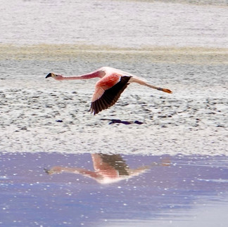


Fauna on the Altiplano (Source: own photos)
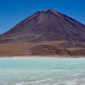
But it is the landscapes that take your breath away. Huge vistas, the deep blue of the big sky, lagoons and salt plains, weird rock formations, hot springs, geysers, and countless volcanoes in a wide range of colours. Let me end this blog by letting my photos do the talking.


The End


I really enjoyed reading about your Southern Altiplano road trip, especially how you described the vast landscapes, salt flats, and colorful mountains that make the region so unique. The extreme altitude and dry conditions you mentioned sound intense but also fascinating. During a busy travel study project, I remember looking for help with assignment uk just to manage everything. It made me realize that experiences like this teach more than books ever can.